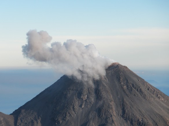
Explosive antics in the field
Colima, Mexico. The goal: unearthing the secrets of Vulcán de Fuego or the “Volcano of Fire”. Fuego erupts roughly every two hours. Nothing major, just an outburst of billowing steam clouds from the summit, generally lasting no more than 10 minutes. These outbursts release pressure in the magma chamber below, and by letting off steam; this active volcano poses little threat to the village of La Añilera, below. However, any change from this typical cycle could hint at an upcoming eruption, so researchers at the University of Colima keep a watchful eye on Fuego’s activity. Today (ahem… some time ago, but we can pretend!), I am playing the part of one such watchful eye.
Dr Nick Varley heads the volcano research team and has logged several years of data from Vulcán de Fuego, which erupts explosively (pyroclastic flows, mudslides, the works!) every 4-5 years on average. Between these large eruptions, the vent is plugged by an extensive rocky mass known as a lava dome. This forms a towering mound of basaltic blocks within the crater walls. Lava domes are common features of many active volcanoes throughout the world and form through viscous lava pushing up from below. A large increase in the temperature of a lava dome is indicative of an upcoming eruption, hence the need to monitor these features.
The best way to view changes in temperature is using a thermal camera, which, with a little technical wizardry, can be used to estimate the temperature of the rocky dome from afar. Most of the time this means making a 3-hour journey by coach, and spending another stomach-churning one in the back of a four-wheel drive to reach the summit of a neighbouring volcano and 5000 metre-high vantage point, Nevado de Colima. From here, the infrared camera is focussed on the volcano and set to capture a series of images over 24-hours, but using photos taken from one volcano to measure the temperature of another is no easy feat! The technical wizardry accounts for things like atmospheric temperature, but distance and cloud cover severely impact results.
To get around this, we need pictures taken closer to the dome; and so I find myself, together with several fellow Volcanologists, in a small and somewhat delicate looking plane circling the volcano in the cool blue dawn. The sun casts its rays on the volcano’s flanks, highlighting the expanse of basalt deposits that scar the landscape. These old lava flows remind me that Fuego is ‘due’ for a big eruption and I wonder whether these deposits will be buried in the next one. Only moments later the summit is alive with steam venting from cracks in the dome and towering into the sky above. The plane veers away sharply and despite much pleading from the volcano-monitoring team – after all, this is the usual quiescent activity – he will go no closer.

Armed with the thermal camera, I am responsible for gathering the data and scramble to lean out of the window for a good shot. Glass prevents infrared rays reaching the camera, so this is more a scientific move rather than an artistic one. Icy air nips at my skin and my eyes stream in the draught as I struggle to handle several thousand pounds worth of camera. Photos from above and to the side allow the volume of the dome to be calculated, as well as recording the temperature. These photos can then be compared with those from the last visit to see whether Fuego is showing signs of unrest. 172 photos and a thoroughly spooked pilot later, we head for home. Now there’s a day in the life of a Volcanologist.
Thanks for taking us on this adventure, Sara. I do sometimes miss fieldwork, though I’ve never been anywhere as exciting as a helicopter over a volcano!
I’m liking it. Especially your blog title.
Hey there! I know this is somewhat off topic but I was wondering if you knew where I could get a
captcha plugin for my comment form? I’m using the same blog platform as yours and I’m having trouble finding one?
Thanks a lot!